Have your kids close their eyes. Ask them to imagine walking through your neighborhood. What do they see? Hear? Smell? Are they in sun or shade? Are they near a park or a parking lot? Do they hear cars whizzing by or birds singing and dogs barking?
While this exercise may seem strange, it’s important for families to reflect on their surroundings. The quality of the environment around us, especially in cities like Richmond, is the result of decades of decisions made by a few powerful people to protect, restrict, maintain, renew, or reshape the collection of landscapes and neighborhoods we call a city. These decisions have a lasting impact on the health and wellbeing of residents.
The relationship between your family’s health and the built environment – or, as the CDC describes it, the totality of physical parts where we live and work such as homes, buildings, streets, open spaces, and infrastructure – is probably most dramatically represented in research and a recent map developed by VCU Center on Society and Health which charts life expectancy in Richmond.
This VCU map suggests that two Richmonders born and raised within five miles of one another (as the crow flies) may have a 20-year difference in their lifespans. Why could this be? While not the only aspect of the social determinants of health – or, according to health.gov, the conditions in the environments where people are born, live, learn, work, play, worship, and age – research has shown that disparities in life expectancy correlate with the amount of environmental amenity within the nearby built environment.
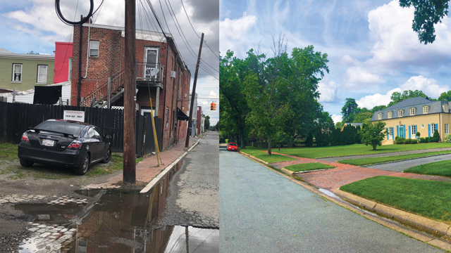
What does that mean? Well, imagine a home on a tree-lined street with a front yard. Now picture a row of homes surrounded by asphalt with no shade trees or landscaping anywhere on the block.
How have the neighborhoods throughout our city come to be so different? Have they always been this way? We can trace at least some of these differences to decisions made by a few people almost a century ago that have helped maintain disparity in the built environment: redlining.
Redlining and Social Health
Redlining was a policy that restricted particular neighborhoods from accessing things like mortgages and homeowner’s insurance largely along racial lines. Starting in the 1930s, it happened in Richmond and throughout the country. Assessors gave neighborhoods one of four ratings: A: best (green outline), B: still desirable (blue outline), C: definitely declining (yellow outline), and D: hazardous (red outline). These ratings were supposed to communicate the neighborhood’s “residential security,” or their mortgage-lending risk.
The hand-written descriptions of the neighborhoods show wealthier, whiter neighborhoods were more likely to garner higher ratings (green and blue outlines), while neighborhoods of color and immigrant communities were more likely to receive lower ratings (yellow and red outlines). The latter also tended to live in older buildings experiencing disrepair, suggesting the neighborhoods themselves would have already had a different built environment – in this case, the quality of the housing – at the time of redlining.
When we look into environmental descriptors in the hand-written notes from decades ago describing neighborhoods, we see C- and D-rated neighborhoods, or the yellow and redlined areas, were described using words that by today’s definition would suggest environmental unpleasantness, such as “odors,” “manufacturing,” “sewers,” and “hot.” Meanwhile, A- and B-rated areas, the green and bluelined neighborhoods, exhibited high levels of environmental quality as they were described with “shade,” “wooded,” and “landscaping.”
Following redlining, a few people made urban planning decisions that impacted many families. Urban renewal, exclusionary zoning laws and blockbusting, and the building of the interstate system of roads all had negative impacts for generations by further segmenting and corralling neighborhoods into the built environment with the disparities we see today.
Environmental and Public Health
Let’s jump back to how we started this piece. Thinking about the historical decisions that lead to neighborhood design is only part of the exercise. Now let’s contemplate how shade from trees, sounds from an interstate, and smells from bus exhaust relate to present-day health outcomes. Can we identify connections between environment and health?
Dozens of peer-reviewed publications have linked redlining maps with disparities in neighborhood environmental amenities and public health outcomes. Similar to the Science Museum of Virginia’s foundational study, multiple groups have confirmed the lack of green space and/or tree canopy in formerly redlined areas compared to their non-redlined neighbors. In Texas, this pattern is echoed by higher rates of outpatient and inpatient heat-related illness admissions for residents of redlined neighborhoods.
Census tracts formed from majority-redlined neighborhoods experience higher amounts of air pollution and are closer in proximity to hazardous waste and EPA Superfund sites. Black adults from redlined neighborhoods score lower on cardiovascular health measures than white neighbors from greenlined areas. Similarly, residents of redlined neighborhoods in California experience asthma-related hospital admissions at higher rates than their non-redlined neighbors.
In New York City and parts of California, preterm birth is more common in formerly redlined areas. Residents of redlined neighborhoods experience worse outcomes after inpatient hospitalization compared to their non-redlined neighbors. Looking more broadly, historically redlined neighborhoods also exhibit higher current-day prevalence of cancer, asthma, poor mental health, and people lacking health insurance.
Green Space Improves Public Health Outcomes
So, what can be done? One tactic seems promising: Increase access to quality green spaces. There’s a ton of space in cities to turn into more beneficial landscapes for all. One estimate puts the amount of vacant or abandoned land in U.S. cities roughly equivalent to the size of Switzerland! By improving underutilized space, which in Richmond tends to occur in formerly redlined areas, we could see reduced feelings of depression and self-reported poor mental health; decreases in crime overall, gun violence, burglary, and nuisances; and increased perceptions of safety and use of outside spaces for socializing.
All this just from improving the built environment? Yes, there is reason to be hopeful. While the studies are limited, the promise is significant. In fact, the City of Richmond is already moving toward increasing access to quality green spaces through dedicating its first new parks in decades, all within the Southside. While this is progress worth celebrating, there’s still more work to do. Additional funding and advocacy are needed to continue transforming underutilized spaces into real places. That work can be the next thought exercise for your family.
Prabir Metha photo for Science Museum of Virginia
